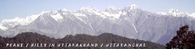
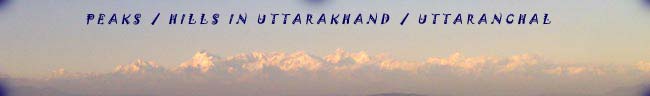
 MUSSOORIE TOURISM : IMPORTANT PEAKS IN UTTARAKHAND | PEAKS / HILLS
IN UTTARAKHAND / UTTARANCHAL
MUSSOORIE TOURISM : IMPORTANT PEAKS IN UTTARAKHAND | PEAKS / HILLS
IN UTTARAKHAND / UTTARANCHAL
.
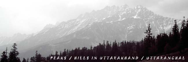
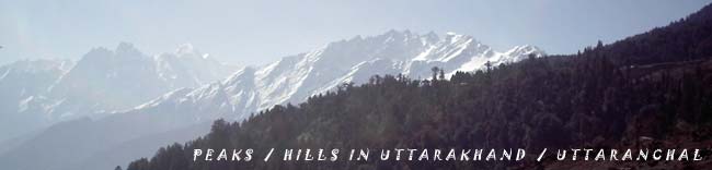
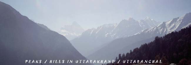
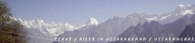
SOME
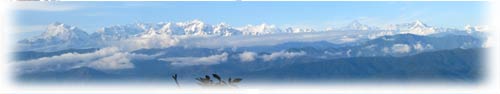
IMPORTANT PEAKS / HILLS IN UTTARAKHAND / UTTARANCHAL
 |
 |
 |
| |
Nanda
Devi
Altitude: 7,817 Mt. Nanda Devi, the
highest of the Garhwal Peaks, which literally means
'Blessed Goddess'. It is considered the pearl of the
Himalayas because of its loveliness. The grace full
symmetry of its twin peaks, the main and the East,
thrusting them up to the sky, is indeed a visual treat-a
rare example of perfect Twin Peaks. It would perhaps
be strange if a mountain of such beauty were not an
object of worship. Infact, since ancient times, inhabitants
of the region have revered this mountain as a dwelling
place of the Gods. The names for mountains and passes
in the area often have religious meanings. Like Kamet,
Nanda Devi refused for years to yield to the many
climbers who tried to overcome her. It is extremely
difficult even to approach her foothills, the entrance
to which is guarded by long, deep gorges. After several
failures, one party finally succeeded in crossing
these gorges and in 1934, entered the south foothills
of the mountain. |
|
|
 |
|
 |
|
|
|
| |
Bandar Punchh West (White Peaks)
Altitude: 6,316 Mts. This Peak lies to
the South West of Kalanak. In June 1950 JTM Gibson with
Tensing Norgay (of Everest Fame) attempted it from the
south. Vertical walls of ice gullies defeated them.
Once climbed, after avoiding the crevasses, and on finally
reaching the corniced top one can get a view of the
steep drop to the southern valley, adjoining ridge of
Bander Punchh and distant Swargarohini peaks. |
|
|
|
|
|
| |
|
|
|
| |
Devtoli
Altitude: 6,788 Mts. The peak lies
to the southern most point on the inner wall of
the Nanda Devi Sanctuary. It is on the Southwest
ring of peaks in line with Maikroli & Mrigthuni
(6,803 & 6855 Mts. respectively). It is at the
junction where the ridge from the Devistan joins
in the south, the ridge between Maikroli & Mrigthuni.
So it stands overlooking the sanctuary in the
east, Trishul Nala in the west & Sunderdhunga
- Tharkot directly below to the south. |
|
|
|
|
|
|
|
|
|
|
| |
Panchchuli Peaks
Altitude: 6,904 Mts. It is believed that
this is the place 'Five Chulis' (cooking hearths) where
the Pandavas cooked their last meal on the way to heaven.
They are majestic and form a famous barrier between
Darma and Gauri Valleys. H. Ruttledge recede it in 1929.
Graaff and Snelson (1950), the Scots (1950) made an
attempt from this side. H.Harrer (1952) tried from the
west finally it was left to two massive Expeditions
by the Indo- Tibet Border Police to open the route (1972)
from the west (Gauri Valley) and make the first ascent
in 1973. On the same divide, a number of fine peaks
merit attention like Nagling, 6,041 Mts. |
|
|
|
|
|
|
|
|
| |
Kagbhusand
Altitude: 5,830 Mts. The historic triangulated
peak of Kagbhusand seems to be guarding the entrance
of Deban plateau. It has graceful shoulders supporting
a delicately soaring peak the top has a shape of Garud
or eagle that is also referred to as Kagbhusand. This
peak is seen from a little above Gamsali, from Gupt
Khal and even from the Girthi gorge. |
|
|
|
|
|
|
|
|
|
| |
Trimukhi Parvat
Altitude: 6,422 Mts. Trimukhi Parvat stands
tall proudly to the southwest. The word literally means mountain
of three faces, a colloquial name Lord Shiva. It has sharp
ice-pinnacle-like in shape. The possible approach can be via
its eastern Col., which has to be reached via long detour
from the Trimukhi Glacier's southern bifurcation. Both the
duration of the approach and the technical difficulties of
the final sections often rule out attempts. |
|
|
|
|
|
|
|
|
| |
Trimukhi Parvat East
Altitude: 6,280 Mts. To the east of the Trimukhi
Parvat is a good shapely separate peak of Trimukhi Parvat
East. |
|
|
|
|
|
|
|
|
| |
Kamet
Altitude: 7,756 Mts. Kamet taken from the word
'Kangrie' which literally means 'lower snow' in Tibet attracted
the first mountaineers.Kamet Peak is the second highest in
the Garhwal and was tried ten times before it fell. F.S. Smythe
of Britain headed the eleventh and victorious climb. One of
companions to the top, R.L. Holdsworth, wore skis up to the
col. 7,025Mts. high. In 1848 Richard Strachy determined its
height, followed by the Schlaginweits. In 1855 they went over
the Mana pass and attempted it from the north reaching 6745
Mts. on Abi Gamin. In 1874-77 the Survey of India under E.C.
Ryall and I.S. Pocock set up a plane table at 22,040 ft on
the slopes of East Abi Gamin these are now identified on modern
maps as Mukut Parvat, Kamet and Abi Gamin respectively. In
fact in 1931, it was while returning from their successful
Kamet expedition that Frank Smith and Holdsworth stumbled
into the valley of Flowers. |
|
|
|
|
|
|
|
|
| |
Neelkanth
Altitude: 6,597 Mts. Neelkanth is a pyramidal snowy peak
towering Above Badrinath. It is popularly known as 'Garhwal
Queen' because of its dramatic sight.No history of central
Garhwal would be complete without a detailed mention of this
majestic peak. It is a dream of the pilgrims. It is a tough
and challenging proposition for mountaineers. |
|
|
|
|
|
|
|
|
| |
Nadakot
Altitude: 6,861 Mts. This 'Fort of Nanda' is an imposing
peak dividing the Gori and Pindari valleys. Dr. Longstaff
in 1905 and 1936 the Japanese made the first ascent on it.
An Indian team in 1956 climbed it again. In 1986 the Indo
Japanese made another ascent to celebrate the fifty years
of their first ascent. |
|
|
|
|
|
|
|
|
| |
Sudarshan Parvat
Altitude: 6,507 Mts. Sudarshan Parvat has beauty
as well as challenge. It is a sight fit for the Gods. Situated
above the Gangotri Temple it has been seen by millions of
pilgrims and mountaineers through the ages. The view from
the top is grand. All the Gangotri Peaks and valley, a little
of Tibet and all the neighboring peaks can be seen. It gets
its name from Sudarshan, the weapon which Lord Krishna or
Vishnu holds in his hand. It is believed to be released in
the ultimate crisis. The history of Sudarshan is brief though
spread over 19 years. It was attempted by 5 expeditions. Mostly
by the west ridge and once of the south ridge. The last attempt
was in 1979 when the climbers reached high on the west ridge.
|
|
|
|
|
|
|
|
|
| |
Chaturbhuj
Altitude: 6,655 Mts. Chaturbhuj, situated
north of Sudarshan Parvat, literally means ' one with four
hands'. This is the name for Lord Vishnu who has four hands
and holds the Sudarshan Chakra. This peak has four distinct
ridged falling in four directions, thus both mythologically
as well as topographically this name is appropriate. The summit
of Chaturbhuj is a conical pyramid, very steep, 15 Mts. long
and 2 Mts. high. |
|
|
|
|
|
|
|
|
| |
Yogeshwar
Altitude: 6,678 Mts. Situated northeast of Sudarshan
Parvat lies Yogeshwar. It takes its name from Lord Krishna,
in a serene mood and thus can be aptly applied to this high
snowy peak. |
|
|
|
|
|
|
|
|
| |
Saife
Altitude: 6,161 Mts. South-southeast of Sudarshan
Parvat lies a gentle yet deceptive peak. Saife in local language
means 'Sword' or the weapon carried by Lord Ram, who is also
known as the God with the white complexion-Swetvarna. This
peak lies near Koteshwar-'God of the Edges'. Thus with sword
edge -like ridges, the name is appropriate. |
|
|
|
|
|
|
|
|
| |
Chandrashila
Altitude: 3,679 Mts. Chandrashila is most
accessible peak of the Uttaranchal Himalayas, especially since
most of the peaks are difficult to scale. A climb to this
mini peak in Chamoli District is arranged by GMVN. This combines
scaling, skiing and trekking through a route of rich flora
and fauna, lakes, meadows full of fresh snow in the winter
month. The chandrashila peaks itself provides a rare panoramic
view of innumerable snow clad peaks. |
|
|
|
|
|
|
|
|
| |
Badrinath
Altitude: 3,133 Mts. Guarded on either side by
the two mountain ranges known as Nar Narayan with the towering
Neelkanth peak providing a splendid backdrop. Badrinath is
one of the Four Dham of the country. |
|
|
|
|
|
|
|
|
| |
Kedarnath
Altitude: 3, Mts. A scenic beauty spot, situated
against the backdrop of the majestic Kedarnath range, the
Kedarnath shrine is one of the twelve 'Jyotirlingas' of Lord
Shiva. |
|
|
|
|
|
|
|
|
| |
Yamunotri
Altitude: 3,235 Mts. In the shadow of the high Bandar
Punchh Mountain lies the source of the sacred river Yamunotri.
This shrine is of paramount religious importance for Hindus
and essential pilgrimage. |
|
|
|
|
|
|
|
|
| |
Gangotri
Altitude: 3,200 Mts. Surrounded by the mountain
peaks of Shivaling, Satopanth and Bhagirathi sisters, this
scared shrine, is the source of river Bhagirathi. |
|
|
|
|
|
|
|
|
| |
Vasukital
Altitude: 4,150 Mts. Offering an excellent view
of Chaukhamba peak, the Vasukital is surrounded by high mountains.
|
|
|
|
|
|
|
|
|
| |
Kedartal
The mighty Thalsagar (Spatikling) peak forms the spectacular
backdrop of the Kedar Lake, which is negotiable through a
rough mountain trail.
Nandanvan
From here the views of Shivaling, Bhagirathi, Sudarshan, Thalu
peaks and Kedar Dome are fabulous.
Guptkashi
From here one can get magnificent view of Chaukhamba peak.
Madmaheshwar
Engulfed by Chaukhamba, Kedarnath and Neelkanth peaks, the
trek from Kalimath to the Madmaheshwar is distinguished by
wild unparalleled scenic beauty.
Gwaldham
Gwaldham is a sylvan Himalayan quaint town surrounded by fruit
orchards. One can have a magnificent view of Nanda Ghunti,
Trishul and Nandadevi peaks. |
|
|
|
|
|
|
|
|
| |
Valley of Bhilangna
The Khatling Glacier is a lateral glacier at the source of
the River Bhilangna. Shastratal and Masartal are on the west
and east of it. The valley of Bhilangna offers panoramic views
of the snow-capped peaks and hanging glaciers, such as Jogin
Group, Kirti Stambh and Meru Parvat, which are sublime and
magnificent. |
|
|
|
|
|
|
|
|
| |
Rudranath
Altitude: 2,286 Mts. Rudranath provides magnificent
view of Hathi Parvat, Nandadevi, Nanda Ghunti and Trishuli
peaks among others. The face of Lord Shiva is worshipped here. |
|
|
|
|
|
|
|
|
| |
Auli
Altitude: 3,050 Mts. The cable car from Joshimath
to Gorson via Auli offers a picturesque view of the Himalayan
ranges. 15 Kms from Joshimath Auli is an ideal venue for winter
sports. |
|
|
|
|
|
|
|
|
| |
Pauri
Altitude: 1,814 Mts. Situated on the northern slopes
of Kandoliya Hills, it provides a panoramic view of the snow-clad
Himalayan Peaks of Bandar Punchh, Swarg-Rohini, Jonli, Gangotri
Group, Jogin Group, Thalaiya-Sagar, Barte Kanta, Kedarnath,
Kharcha Kund, Sumeru, Satopanth, Chaukhamba, Neelkanth, Gauri
Parvat, Hathi Parvat, Dronagiri, Nandadevi and Trishul. |
|
|
|
|
|
|
|
|
| |
Chaukori
Altitude: 2,010 Mts. The charming and picturesque
town of Chaukori is situated in the heart of Pithoragarh district,
close to the famed Jim Corbett Park. Chaukori is famous not
only for the magnificent view it offers of Panchchuli, but
also for its breathtaking beautiful sunsets. |
|
|
|
|
|
|
|
|
| |
Pithoragarh
Altitude: 1,650 Mts. The easternmost hill district
of Uttaranchal, Pithoragarh is often referred at as "Miniature
Kashmir'. From the Chandak hill located at around 2000 Mts.,
one gets a panoramic view of snow ranges extending from Trishul-Nanda
Devi, Panchchuli Group and Mount Appi of Nepal. |
|
|
|
|
|
|
|
|
| |
Munsiyari
Altitude: 2,289 Mts. Munsiyari is the centers as
well as the Gateway of Johar region, offers Panoramic view
of snow capped peaks of Panchchuli. |
|
|
|
|
|
|
|
|
| |
Kausani
Nestling among thick, dense forests atop a narrow ridge and
separated from the towering mountains of the Nanda Devi range
by low, medium mountains; at Kausani the grandeur of the Himalayan
scenery comes alive. The view of the snow covered Trishul
and Nanda Devi is so clear that one gets a feeling of the
snow being within touching distance. |
|
|
|
|
|
|
|
|
| |
Binsar
Binsar is one of the most scenic spots in the Kumaon Himalayas
and an acclaimed hill resort. The main attraction of Binsar
is the majestic view of the Himalayas. A 300 Kms. stretch
of famous peaks, which includes Kedarnath, Chaukhamba, Trishul,
Nanda Devi, Nanda Kot and Panchchuli. |
|
|
|
|
|
|
|
|
| |
Ranikhet
A cantonment of immense charm, Ranikhet was selected as a
hill station for British troops and accordingly the Cantonment
was established in 1969. Ranikhet provides magnificent view
of the Chaukhamba, Kedarnath, Kamet, Hathi Parvat and Panchchuli
peaks. |
|
|
|
|
|
|
|
|
| |
Almora
Altitude: 1,646 Mts. Perched atop a 5 kms long
saddle shaped ridge of Kashya Hill. Almora is a charming Mountain
resort in the Himalayas providing magnificent views of snow
capped Chaukhamba, Neelkanth and Kamet peaks. |
|
|
|
|
|
|
|
|
| |
Champawat
Altitude: 1,615 Mts. Champawat was originally the
capital of Chand Rajas of Kumaon and is now the District Headquarter.
Champawat is famous not only from Historical, Sculptural and
archaeological point of view but also for it's abundant scenic
beauty. From here the view of Panchchuli Ranges is unique. |
|
|
|
|
|
|
|
|
| |
Sitalakhet
Sitalakhet is a scenic spot commanding a view of majestic
Himalayas. One can get a Panoramic and Magnificent view of
Chaukhamba, Kamet, Hathi Parvat, Trishul, Nanda Devi and Nand
Kot Peaks. |
|
|
|
|
|
|
|
|
| |
NAINA PEAK
Previously known as CHINA PEAK Naina Peak :- An altitude of
2,615 m (8,579 ft). The highest peak of Nainital provides
a challenge to the most avid trekkers. Situated about 6 kms
(4 miles) from Mallital. Naina Peak is known for its splendid
Bird's eye view of the town, the Himalayas and also the vast
expanses of the Terai regions of Kumaon. |
|
|
|
|
|
Email: booking@mussoorietourism.in
|